C2C = Cycle to Cafe. Circular routes from Goring designed as much for a friendly cafe or two as for the lovely scenery and enjoyable riding.
Swyncombe and Dorchester off-road
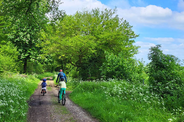
A mainly off-road tour of what’s best about cycling in the Chilterns and Thames Valley
Highlights
Lots of them – bluebells in the spring, the Early Norman church, of St Botolph at Swyncombe, a delightful easy bridleway down a dry valley (pictured above), the historic villages of Ewelme and Dorchester, Wittenham Clumps with its Iron Age hill fort. If that’s not enough, there’s also a refreshment stop on an alpaca farm, locations from Midsomer Murders, riverside bridleways and close-up views of Wallingford Castle, once one of the most powerful royal castles in the land.
Hazards
The stretch of route between Roke and Dorchester is flat, across open fields. It should be avoided if there is any chance of thunderstorms.
Traffic at crossings or on short sections of local A or B roads.
Hospitality
Blue Tin Farm Shop (open Wed – Sat) is on route at the top of the off-road climb from Braziers College (4.7 miles)
The route passes through Bishop’s Court Farm in Dorchester to visit the Snug cafe and farm shop (20 miles), and uses a permissive track next to the alpaca fields. There is an alternative publice bridleway 200 yards to the east that does not pass through the farm.
Village shop in Ewelme (14 miles) , lots of choice in Wallingford.
Hints
This route is suitable for being split into chunks or just made shorter, by taking minor roads from Ewelme to Wallingford or directly back to Goring. See the Swyncombe and Ewelme or the Tour des Clumps road routes.
The route finishes at the west entrance to Goring & Streatley station, to use quieter roads through the village. The station has bike-friendly lifts.
Goring to Reading off-road via Kidmore End
Mainly off-road route through the Chilterns from Goring to Reading
Highlights
A great away-from-it-all way of getting to Reading.
Classic Chiltern woodlands with direction arrows on beech trees, bluebells in spring and mud where there is clay on top of the chalk.
Hazards
The stretch of Beech Lane where it enters the woods above Goring can be very muddy, to the extent there is often a little detour path through the trees around the worst bit.
The descent from Tanner’s Lane to Bugs Bottom is quite steep and is the main reason this route is more suitable for mountain bikes than hybrids.
Hospitality
The route passes the Coop supermarket in Woodcote (3.4 miles). The New Inn pub in Kidmore End is near the route at 8.5 miles.
Lots of choice in Caversham
Hints
The route coincides with a short length of National Cycle Route 5 southeast of Kidmore End. However it takes the bridleway descent to Bugs Bottom in preference to NC5 into Caversham, which ends in a flight of steps down the side of a recreation ground.
Essential Reading
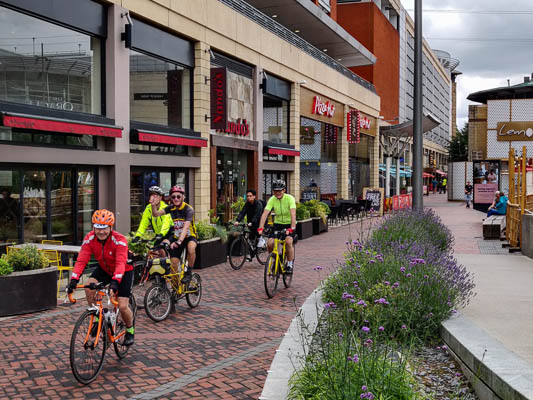
A traffic-free route through the major commercial centre that is Reading
Highlights
For 10 miles from Theale to Sonning the route follows National Cycle Route 4 along the rivers Kennet and Thames, providing a traffic-free exploration of the town.
Some other parts of the route are also traffic-free and quite rural.
Hazards
Busy traffic in Pangbourne town centre
Some narrow sections of towpath with tight turns and bridges, on the canal west of Reading.
A blind corner on part of the towpath used by commuting cyclists (at 14.9 miiles)
Shoppers and others wandering around at The Oracle. It is a perfectly legally cycling route, but cyclists should take care and give way to pedestrians.
Busy traffic on the road from Sonning to Playhatch
Hospitality
Cafes in Pangbourne (4.6 miles), Theale (8.5 miles) and The Oracle area of Reading (15.6 miles).
The route takes a short detour at 17.5 miles to visit the Park Kitchen cafe at Thames Valley Park, mainly because of its pleasant setting.
Hints
Reading may no longer be famous for “Beer, Bulbs and Biscuits”, but traces of its industrial heritage are still to be seen. The route passes the site of the former Simonds Brewery and follows the River Kennet through what was once known as Brewery Gut and is now The Oracle shopping centre. Further downstream it passes the Huntley and Palmers biscuit factory, now offices and apartments.
Watership Down
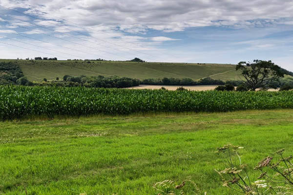
A foray into Hampshire to pay homage to Richard Adams’ famous book about rabbits migrating in the face of development
Highlights
Quiet lanes in rural North Hampshire; the beautiful Bagnor Valley (in West Berkshire)
Hazards
Two crossings of the A4. The rest of the route is relatively quiet.
Hospitality
The Blackbird cafe (10.2 miles)
Molly’s Village Cafe (12.4 miles)
Honesty Kingsclere cafe (quarter of a mile east of the route at 20 miles)
Yew Tree Garden Centre, Balls Hill (30 miles)
Hampstead Norrey Community Shop (quarter of a mile east of the route at 46 miles)
Hints
The route runs along the foot of Watership Down, which forms part of the Hampshire Downs escarpment. Tackling the climb is not part of the mapped route, but could be taken on as an optional extra, with a mile’s out-and-back detour. The nearest point on the route has an elevation of 129 m, the summit of the road climb is 204m and of the down itself 237 m.